

After losing all their possessions in a great flood of the Gamtoos River in 1906, my paternal grand- parents purchased 3 plots in an isolated hamlet called Schoenmakerskop during July 1918. On erf 17 – what was to become Number 32 Marine Drive – they constructed a wooden restaurant, which in its early years was called “The Hut”. With only a limestone and sand road from Walmer, their customers must have been paltry. Against the odds, luck was on their side. On Wednesday 6th December 1922, Marine Drive was opened. It became a magnet for the rich and well-heeled in Port Elizabeth. Soon The Hut was overflowing with customers and the whole family was pressed into service catering for this demand.
This blog is a pictorial replication of that drive on Sunday 10th December 1922 with contemporary photographs and drawings.
Main Picture: The start of the drive was at the Port Elizabeth Town Hall. One hundred and fifty model T Fords line up to make the journey around the Marine Drive. This is the actual photograph of the vehicles lining up.
Whose idea it was to meet in Market Square outside the Town Hall and to drive around the recently opened Marine Drive is lost in the mists of time. Perhaps it was the novelty factor of being able to view this recently opened coastal road or perhaps it was merely the hype generated by the news report in the local newspaper, the Eastern Province Herald. But whoever it was, was aware that the idea would attract the wealthy denizens of Port Elizabeth to flaunt their cars to everybody else.
In 1922 car ownership was restricted to the extremely wealth in Port Elizabeth with less than one percent of the citizens owning a car. Within the town itself the favoured mode of transport was still the electric tram which had entered service in 1897.
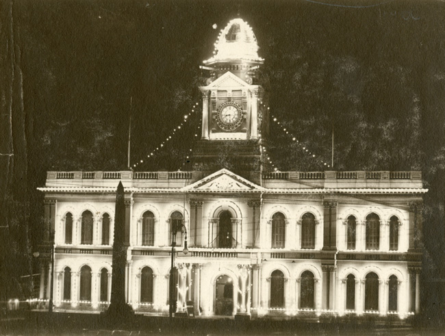
The agreed meeting place was in Market Square outside the Town Hall. This building had been the focus of the town since its opening in 1862. The buildings surrounding the stately Town Hall were equally as grandiose in their own right.
Opposite the City Hall – it had only been called a City from 1913 – was the Main Library with its twin turrets on each wing. In front of it was the impressive white marble statue of Queen Victoria who had died on the 22nd January 1901. At the time of the Queen’s Diamond Jubilee in 1897 a movement to raise funds for the statue was started. E. Roscoe Mullins, a renowned sculptor from London at the time, was commissioned to sculpt the statue which is made from Sicilian marble.

Glancing further west, one was able to view the whole of Collegiate Church of St Mary the Virgin. Later the portion of the plot abutting Main Street would be sold for the erection of the six storey UBS building effectively dividing the road frontage into two.

The future members of the Church probably rued the day that the plot had been sold for the paltry sum of £160. The Church was founded at a meeting of citizens under the chairmanship of Captain Francis Evatt on 26 April 1824. The foundation stone of the Church building was laid on 5 October 1825, and in the same month, the Rev. Francis McCleland arrived to take up the post of Colonial Chaplain and minister of the church. The building was opened for worship in 1832. It was described as being not very imposing, oblong with a red tiled roof. External alterations and additions were made in 1860. In 1895 the church was burned down but was rebuilt within a year and opened for worship on 6 September 1896. Paul Kruger sent a donation and Cecil John Rhodes paid for the cloisters.

Being a Sunday, there were no carts in Main Street apart from a solitary tram. Aside from that, as all the shops had been closed since lunch time on Saturday, the streets were deserted, devoid of people.

In 1922, the Port Elizabeth harbour was still one of the foremost harbours in South Africa eclipsing that of Durban even though the main quay, the Charl Malan, had not yet been constructed.

Down Jetty Street was the source of great revenue: Customs House

After admiring one another’s cars, much like a latter day Harley Davidson devotees gathering, it was time to go. Some cars had to be crank started whereas the other drivers whose cars had starter motors sat smugly viewing their neighbour’s exertions.
Further down Jetty Street was the Campanile which had recently been opened. The Campanile had been erected to commemorate the landing of the 1820 Settlers and is situated at the entrance to the railway station and docks in Strand Street. This is the spot where it is claimed that the settlers landed in Port Elizabeth. The architects were Jones & McWilliams with construction starting in 1920 and it was completed in 1922.

Finally the convoy was off, slowly passing the Main Post Office.

After less than a kilometre, the Baakens River was reached. The source of this river was in the Greenbushes area and its mouth was in the Harbour.

On the banks of the stream were the Tram Sheds.

All of the drivers could recall the flood of 1908 in which this once placid stream morphed into a raging river almost sweeping the buildings away.
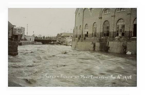
In the background, the Baakens River power station could be seen. The water from the river was used for cooling purposes in the plant.

With their puny engines, most of the vehicles had to change down as they climbed the hill along South Union Street to Walmer Road. This area was eponymously called South End but it was known as the “place across the river”. At the intersection with Walmer Road, was the Seaman’s Institute.

The tram line into Walmer turned right at this point up Walmer Road.

As Humewood had only been opened up in the 20th century, most of the stands were still vacant. The railway line which had transversed this road carrying the town’s rubbish over the puny Shark River before veering west to the driftsands where it would discharge its cargo, had long since been removed tobe replaced by a tram line. Just before the vehicles reached the main beach, the Humewood Beach, they passed the location where Beach Humewood Hotel had once stood. This wood and iron building was burnt down in 1915 and it was only in1927 that the Municipality had erected its replacement, the original Elizabeth Hotel.

Here they would encounter their first cars since setting off. They were parked along the Humewood beachfront.

The first stop was at the Bathing House in order to stretch their legs. With the state of the roads and their cars lack of power, it had been a slow journey of 30kph.

Some even sauntered across to the Octagon building in order to ascertain whether it would cast a spell on them.

Then it was time to proceed. Over the Shark River and then past the slipway

At the top of the slipway was a boat which had been hauled up for inspection and repairs.
This was literally the end of the line; the tram line.

By now the outskirts of town had been reached. Latter day Summerstrand had not yet been developed so in fact this was now open country. The whole area was covered in shifting white sand. Sand dunes covered the whole area from the sea, across Summerstrand formerly known as Strandfontein, past the airport. The furthest point that these driftsands reached was Gluchways in the Sardinia Bay / Bushie Park area where the Lovemore’s now live.
Before the motorists skirted inland past the Lighthouse, they knew that Cape Recife was nearby. Thousands of seagulls and other sea birds squawked and mewed in the sky swooping and diving as they did so. This light house had been built in 1851 and had saved many a ship from the Thunderbolt Reef close inshore.

The convoy sailed on, passing Noordhoek and Willows, both of which were virgin bush with no human settlements.
Finally they reached the outskirts of Schoenmakerskop. All the inhabitants were waiting in expectation. Many had never seen a vehicle beforehand. A frisson of excitement swept through the community.
The first resident to spot the convoy was Mr Arthur Braidwood Gibbon at No 5 Periwinkle Lane. He was purchased the stand in 1918. The bungalow shown in the picture was built with wood fetched by ox wagon from the wreck of the tug “James Searle” which ran ashore at Chelsea Point in the Noordhoek area in 1901.

Outside number 76 Marine Drive was Phillipa & Alwyn Dufour Clarke. They had purchased the plot from Mr WKC Hustler in 1920. Between them they had built a house on the plot. The timber used in its construction was ironically motor car packing cases which they had covered with bituminous sheeting as was the roof. Another unusual feature of its construction was that the cottage was built on a foundation of large round stones.

Next door at number 74, was Mrs CA Bedford’s hotel eponymously named Bedford’s Private Hotel.

Many of the plots before the tearoom / restaurant were still vacant plots in 1922. At number 44 were the Woods. Harry Wood had purchased the plot in 1918 and immediately built a wooden house on the stand with the assistance of his two sons, George – my aunt’s husband – and Clarence. During 1919 the floor boards of the kitchen and bedroom was re-laid with wood which they had collected from shipwrecks on the beaches of Schoenmakerskop.
During 1922 Harry transferred ownership to his two sons, one of which Clarence was to stay there for the rest of his life.
During the late 1960’s and early 1970’s Blaine – my brother – and I stored our home-made canoe under one the Norfolk pines in the yard.

At number 40 Marine Drive lived the Gluckman family. Mrs Johanna Gluckman had purchased the cottage in 1918 for £20.

At number 36 was the Master’s family
In spite of a huge green commons in front of number 32 Marine Drive, it was jam packed with cars.

This was their destination, The Hut owned and managed by Mrs Elizabeth Daisy McCleland, known as Daisy to all and sundry. In attendance were her three daughters: Thelma, Kathleen and Maureen. Assisting with the hard manual labour was an 11 year old boy, Harry Clifford McCleland – my father – known as Cliffie, who had to make the cream. Thirty years later at the age of 41, he would sire me, his eldest child.

Clifford’s youngest brother, Bryce Beckley McCleland, was more of a hindrance than assistance as he was only 3 and ½ years old. His older brother by two years, Francis McCleland, was also assigned some other task.
Somehow between the family members they coped. The multitude was fed and watered. Granny Mac’s restaurant was on the map. Finally in 1942, after 20 years of running this restaurant, she retired, moving to River Road Walmer.

Daisy had left behind a enduring legacy both in running this restaurant and as matriarch of the family.
Footnote
According to Harradine’s Social Chronicle which is the bible on old Port Elizabeth, the Marine Drive was opened on Wednesday the 6th December 1922. What is in dispute is the date of the motorcade around the coast from the Town Hall. For the purposes of this blog, I have accepted the date Sunday 10th but being an era during which religion played a significant part in society’s life, it might well have been Saturday 9th.
Sources
Port Elizabeth: A Social Chronicle to the end of 1945 by Margaret Harradine (2004, Historical Society of Port Elizabeth, Port Elizabeth) Darling would you like a string of Pearls or a house at Schoenmakerskop? by Joan Shaw(Undated, privately published)
Blogs on the PE of yore:
Port Elizabeth of Yore: Russell Road-Formerly Burial or Hyman’s Kloof
Port Elizabeth of Yore: The Road through Target 3Kloof & its Predecessors
Port Elizabeth of Yore: The Parsonage House at No. 7 Castle Hill
Port Elizabeth of Yore: The Great Flood of 1st September 1968
http:// http://thecasualobserver.co.za/the-friendly-city-port-elizabeth-my-home-town/
Sources of information on the Schoenmakerskop of yore:
Many thanks to Mr Robert Gooseman and Mrs Joan Shaw both long term residents of Schoenmakerskop. Without them the historical aspects of this hamlet would never have been told.
What a wonderful and nostalgic article. Loved the old photos.
Great article. The pic of Cape Recife is actually the light house on Bird Island, with gannets in the foreground.
Hi Greg, Thanks for that correction
Greg Hofmeyr is wrong. The photo is in fact of Cape Recife Lighthouse viewed from the seaward side. However I have a problem with the caption of this photo; the lighthouse dates from 1851, but the photo is much later, probably the one from Portnet’s brochure ‘Lighthouses of South Africa’, which was published in 1991.
Regards
Richard Tomlinson, Historical Society of Port Elizabeth
Thanks
The photo of the Bird Island Lighthouse has been replaced by one of the Cape Recife Lighthouse. The original photograph, that I was refering to in my earlier post, was of the BI Lighthouse.
Magnificent.
HI, Are you from Port Elizabeth?
I was born in Port Elizabeth in 1936 and remember all the buildings. Towards to the of this video, Johanna Gluckman’s name is mentioned. She was my father’s aunt .. his mother’s sister.
Brought back many memories. I now live in Cape Town.
Elsa Chapman (nee Cimbelman) ex 22 Walton Road, Mill Park.
This was a wonderful read and some of the photos I have never seen before and enjoyed enormously – THANK YOU!
Thank you Dean for the very interesting account. I enjoyed the ‘trip around’ the Marine Drive. It was wonderful seeing the ‘more recently built’ houses at Schoenies – I remember them well from our Sunday afternoon drives when I was a child. In fact I remember them from the 1960s as well. Are there many left? The buildings in Port Elizabeth are just too exquisite. We were brought up with them and I for one just took them for granted. Now I live in a very recently established area with only new buildings and high rise holiday units. We are indeed blessed to be able to call Port Elizabeth ‘home’.
Lynette McWilliams Troughton. until 1976 37 Thomas Road, Walmer and now Sunshine Coast Queensland Austraia.
Hi, As I have not been to PE for 37 years, I do not know whether any of the original houses still exist but I doubt it. All recent photos seems to show only brick houses
I grew up in number 76 – Schoenies, my best memories were made there. We had 2 long drops in the back yard – I was always petrified of them.
Beneath the house were 2 attics. My father and I had found newspapers buried, dating back to the 1940’s.
Wow, memories
Thank you
Hi Talia, Actually I have written a number of blogs on Schoenmarkerskop. My grandmother started the cafe / tea room circa 1910 & lived there until the early 1950s. The Woods of Schoenmakerskop were my aunt’s family. If you have any photos of old Schoenies, I would really appreciate it if you could email them to me at deanm@orangedotdesigns.co.za.
Kind regards
Dean McCleland
I believe the river you call the Shark started out as the Snark River
Hi Dave,
Close but no cigar. It was called the Sak River after the fact that it just disappeared into the sand at its mouth
Dean
Your reply flashed a memory, my Dad (1945) said the “Sark” River.
I wish to follow up on both words now, English and Afrikaans.
I am almost 100 % the English name was Sark
Thank you for the response my interest is re-awoken.
Hi Dave,
I bow to your superior knowledge but somewhere it stated that it was Sak = Fall
Dean
I bow to your superior knowledge
Sorry – I will leave now.