

For me and possibly other Port Elizabethians, the road up Cooper’s Kloof, commonly known as Albany Road, does not have the same prominence or cachet of either Russell or White’s Road. Nevertheless, it does serve as a vital arterial road carrying traffic both to Cape Road and through to Walmer via Target Kloof.
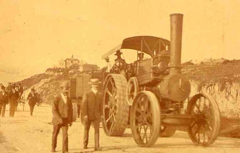
Main picture: Albany Road in 1865
Cooper’s Kloof as a deep gully
Prior to the kloof becoming a road, Cooper’s Kloof was a deep gully and with the hills being barren and devoid of vegetation, whenever there was heavy rain, a strong rush of ebullient water would gush down the valley. To enable the storm water to reach the sea via South Street, a large brick arch was constructed under the road at Princes Street. Originally Princes Street was the portion between Albany Road and Crawford Street of what became an extension of Main Street. The water then continued onwards by way of another gully, now Empire Lane down to the sea.
Albany Road was originally known as Cooper’s Kloof and it appears as such in the 1899 directory but by 1909 Albany Road is listed. It was possibly named after the Duke of Albany but more likely after the Albany District per H.E. Meyer’s notes. Cooper’s Kloof derived its name from the red-tiled house that stood all alone at the foot of the Kloof which was owned by a shoemaker named Mr Cooper. Moreover the first row of houses erected in this vicinity was called Cooper’s Cottages. Later John Berry opened a butcher’s shop on the site of what was to subsequently become known as Murray’s Corner.


The only possible routes up the hill from the shore were the three kloofs which cut deep gulleys from the plateau to the sandy littoral. Prior to the construction of Albany Road Cooper’s Kloof was a stony, rugged Kloof with deep pools of water where children swam and caught fish.

The first kloof to be converted from a rugged stony stream into a road was White’s Road in1850 with Russell Road following in 1863. In September 1865, the construction of a road up Cooper’s Kloof was commenced. According to Margaret Harradine, “This work was undertaken to provide employment during the depression then gripping the country. In July 1866, the Municipality was granted a large piece of land at the top of the Kloof to provide the funds for it. Stone removed during the work was used to build the Wool Market.”
Distress relief work
Disruptive and debilitating would be inadequate descriptors of the consequences of the drought during the early 1880s. Ultimately it caused a deep economic recession and severe hardships due to retrenchments, insolvencies and general unemployment. During such times of distress, a conflict between “our worst instincts and our better angels” arises. In this case, the Town Council’s better angels won the tug-of-war. A Distress Relief Committee was formed and the Council employed labour on public works.
During 1884, the one site of Public Works in operation was employing men at two shillings and sixpence per day in the quarry at Cooper’s Kloof. This relief work was given by the Town Council to the ratepayers and in those days, tenants were also ratepayers. Apparently the men were only allowed to work for one day at a time in order to enable others to have a chance to work.
Fire Station
The Albany Road fire station was opened in 1930. The station served the entire Port Elizabeth city until 1966 when another station was built at Sidwell.

This group of beautiful buildings in the Art Nouveau style comprised the station and blocks of flats around the main building to house the firemen. The old buildings were later sold for commercial purposes and the flats to private owners.
In September 1939 the City’s first automatic traffic signals were erected at the intersection of Russell Road, Queen, Griffin and Main Streets. The traffic signals were highly successful and a second set was installed at the intersection of Albany and Westbourne Roads.
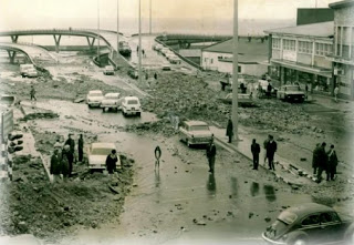
1968 Floods
On 1 September 1968, 429 mm of rain swamped the city. In a single day the highest rainfall figure in living memory was recorded and as such reported in the Eastern Cape Herald newspaper. The devastating flood took the lives of at least five people and 30 or more were rescued. Cars and caravans were swept down the Baakens River, a normally docile stream yet prone to flooding. Eyewitness reports speak of cars bobbing like corks before being dumped further downstream.

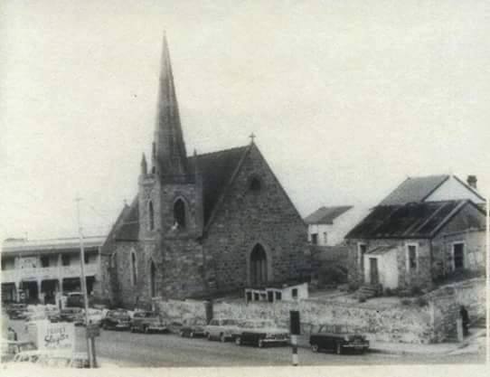
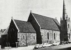
St. Paul’s Anglican Church

With the town rapidly expanding, the need for a 2nd Anglican Church in Port Elizabeth arose. During an age with neither public transport nor private motor vehicles, churches had to be located within walking distance of their congregants. During both of his visits in 1848 & 1850, Bishop Gray had pointed out the need for a church in North End with a capacity of 200 to 250 congregants to serve the needs of the local Anglicans. This church, he suggested, should be built on land offered by Mr Tee and Mr Korsten.

Central to its construction, was the need to raise funds and then secondly to appoint a clergyman. Contrary to expectations, a substantial portion of the funds were raised or pledged over a short period. Without it sounding too blunt and matter-of-matter, Bishop Gray simultaneously requested a clergyman from Britain and explained the situation as follows. “No man would be too good, but there is nothing to tempt any one. A new district Parish out of a colonial sea port, with no stipend except what will arise from the Offertory.” An offertory is the offering or collection of money made during a religious service.

St Paul’s Church was built between 1854 and 1856 at the corner of Govan Mbeki Street and Albany Road – at that time called Queen Street and Cooper’s Kloof respectively. The foundation stone was laid by the first Bishop of Grahamstown, John Armstrong, on St Luke’s day, 18 October 1854.
Painting by Edwina Smyth entitled “Port Elizabeth at sunset from McKay’s veranda” showing St Paul’s Church. The date on which it was painted is unknown

In 1959, St. Paul’s Anglican Church had to be demolished to enable Albany Road to be widened.

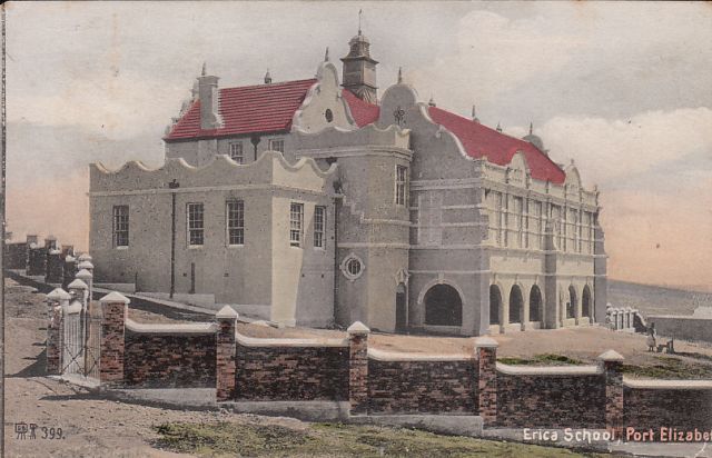
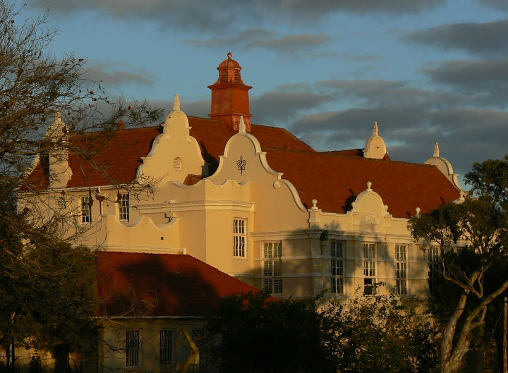
Erica School for Girls
In the background above the old Fire Station, another Richmond Hill landmark, the old Erica School for Girls, can be seen. One of the earliest schools for girls in Port Elizabeth was the Erica School, which started out in a couple of cottages next to the headmistress’ home in Richmond Hill. This lovely building was opened in 1903, on the edge of Richmond Park, with commanding views over the bay. The school eventually outgrew it and moved on, and the building is now used for the art department of one of our colleges offering Tertiary education.
Five Ways
At the top of Albany Road, is the iconic Five Ways, technically now four ways.


Other photos

Sources:
Port Elizabeth in Bygone Days by JJ Redgrave
Port Elizabeth: A Social Chronicle to the End of 1945 by Margaret Harradine
The Bay of Living Memories by Voullaire (Looking Bay, Volume 55, 2016)
Related blogs:
Algoa Bay before the Settlers: Sojourn by Henry Lichtenstein in the Early 1800s
Algoa Bay before the Settlers: Sojourn by Henry Lichtenstein in the Early 1800s
Port Elizabeth of Yore: Captain Jacob Glen Cuyler
Port Elizabeth of Yore: Captain Jacob Glen Cuyler – A Man of Many Parts
Port Elizabeth of Yore: The Growth of the Population
Port Elizabeth of Yore: Murders most Foul
Port Elizabeth of Yore: The Phoenix Hotel
Port Elizabeth of Yore: Echoes of a Far off War
Port Elizabeth of Yore: Main Street in the Tram Era
Lost Artefacts of Port Elizabeth: Customs House
The Great Flood in Port Elizabeth on 1st September 1968
Port Elizabeth of Yore: The Great Flood of 1st September 1968
A Sunday Drive to Schoenmakerskop in 1922
Port Elizabeth of Yore: Horse Drawn Trams
Port Elizabeth of Yore: Trinder Square
The Sad Demise of the Boet Erasmus Stadium
Interesting Old Buildings in Central Port Elizabeth:
The Shameful Destruction of Port Elizabeth’s German Club in 1915:
Port Elizabeth of Yore: Shameful Torching of the German Club in 1915
Port Elizabeth of Yore: Cora Terrace:
Port Elizabeth of Yore: Cora Terrace-Luxury Living on the Hill
Port Elizabeth of Yore: The Grand Hotel:
Port Elizabeth of Yore: Whaling in Algoa Bay:
Port Elizabeth of Yore: Whaling-From Abundance to Near Extinction
Port Elizabeth of Yore: White’s Road:
Port Elizabeth of Yore: The Slipway in Humewood:
Port Elizabeth of Yore: King’s Beach:
Port Elizabeth of Yore: Russell Road:
Port Elizabeth of Yore: Russell Road-Formerly Burial or Hyman’s Kloof
Port Elizabeth of Yore: Sand dunes, Inhabitants and Animals:
Port Elizabeth of Yore: The Horse Memorial:
Port Elizabeth of Yore: Target Kloof:
Port Elizabeth of Yore: The Road through Target 3Kloof & its Predecessors
The Parsonage House at Number 7 Castle Hill Port Elizabeth
Port Elizabeth of Yore: The Parsonage House at No. 7 Castle Hill
What happened to the Shark River in Port Elizabeth?
A Pictorial History of the Campanile in Port Elizabeth
Allister Miller: A South African Air Pioneer & his Connection with Port Elizabeth
Allister Miller: A South African Air Pioneer & his Connection with Port Elizabeth
The Three Eras of the Historic Port Elizabeth Harbour
http://thecasualobserver.co.za/the-three-eras-of-the-historic-port-elizabeth-harbour/
The Historical Port Elizabeth Railway Station
The Friendly City – Port Elizabeth – My Home Town
Port Elizabeth of Yore: Russell Road Methodist Church – 1872 to 1966
Port Elizabeth of Yore: Russell Road Methodist Church – 1872 to 1966
The Royal Visit to Port Elizabeth in 1947
Port Elizabeth of Yore: Main Street before the Era of Trams