

Like all sea routes, Algoa Bay is fraught with hazards. Amongst them is Roman Rocks which is 2.5 kilometres off Humewood Beach. The problem is that it is lies 3m below the surface at low tide, thus being treacherous for foolish or unwary ship’s captains.
Main picture: Buoy off Roman Rock
History
Dispatch Rock, as it was initially known to the British Navy, was chartered by Lt William McPherson in 1797 and named eponymously after the H.M.S Dispatch. It stands about a mile off Beacon Point and has only 14 feet [3 metres] of water above it at low water. Formerly it was only indicated by two beacons placed on shore but after 1838 a light-and-bell buoy was anchored over the reef, but it was soon washed away. In 1843 another buoy was secured to it and an official notification was placed in then Government Gazette renaming it Roman Rock.

In a letter by the Port Elizabeth Harbour Master Dunsterville dated 22nd April 1843 to the Colonial Secretary in Cape Town, Dunsterville states the following: “The Steam Navigation Co. placed a beacon to point out the position of Roman Rock. In a notice to the mariners he added: Black spar with a red band across the top and the words ‘Roman Rock’ painted on it and it floats about 7′ above the surface. Safe passage between the beacon and the shore. Outside beacon must keep 3/4 mile out from beacon”.
Amongst the first recorded sinking on Roman Rocks, as it was later called, was the bark H.M.S. ‘Balaklava’ which struck the pinnacle on 14th May, 1867. She began taking in water rapidly and a special pump belonging to the P.E. fire brigade was dispatched by tug in an attempt to save her, but she suddenly sank in seven fathoms of water. There was just sufficient time to take the crew aboard the tug. In the cargo were two stained glass windows intended for Holy Trinity Church.
In 1934, Roman Rocks claimed another victim, the ‘Paris Maru’. On Monday 15th January 1934, the 7197 ton Japanese freighter left the harbour after discharging cargo to sail to Cape Town. She was hardly under way when she struck the Roman Rock off Beacon Point.

She began to flood rapidly but the captain turned her and tried to make his way back to the harbour. All the crew except the captain and five others took to the boats and landed safely. She was now down by the bows and the propellers could not function. She drifted past the end of the Charl Malan Quay and on towards the North End beach. The tug ‘James Searle’ stood by and took off the captain and the rest of the crew just before the ship suddenly spouted like a whale and sank. Unsuccessful attempts were made to salvage her, but she was finally destroyed by explosives to prevent her becoming a danger to shipping. The tragedy of it was that this was Captain Jogetu’s first command.
This reef is known as Roman Rocks due to the large number of red roman fish that are found here. The extensive reef is made up of gullies and pinnacles and is teeming with fish, soft corals, feather stars, starfish, sea fans and anemones.

Current situation
Today an East Cardinal marker buoy warns ships to pass on the eastern side. At night a flashing light marks the location of the reef. There is of course a bell on this buoy to warn ships when fog rolls into Algoa Bay, hence the name Bell Buoy.
This reef is known as Roman Rocks due to the large number of red roman fish that are found here. The extensive reef is made up of gullies and pinnacles and is teeming with fish, soft corals, feather stars, starfish, sea fans and anemones.

Nowadays Roman Rocks is better known for adventurous sports. As it is marked by a Bell Buoy, it is the turning point of the Nelson Mandela Bay Bell Buoy Challenge, a 5 km ocean swim, reputedly one of the toughest in the world.
The Bell Buoy crossing (Hobie Beach to Bell Buoy and back) was achieved for the first time in 2009 by Eastern Cape solo swimmer Kyle Main. On the back of Kyle’s 2009 double crossing, the Nelson Mandela Bay Bell Buoy Challenge has been established as an open water ocean swim of 8km from the city’s pristine blue flag Hobie Beach to the Nautical Bell Buoy, situated some 2.5km offshore and 3.5km from Hobie Beach, and back.

Main, who has built a reputation on attempting long-distance solo open-water swims, found himself among a school of about 200 dolphins during his Bell Buoy swim. “Dolphins are par for the course for long swims in the bay. The swim was slightly tougher than expected, especially due to the currents around the bell buoy and on the way back. The wind was also not in my favour, being offshore (a westerly) at the time and I suspect an easterly would have been slightly easier.” Kyle Main
In reality, Roman Rocks does not merely comprise a single pinnacle but it is an extensive reef covering a large area. With plenty of pinnacles and gullies to explore, it is an ideal diving site and cannot be covered in one dive. Four distinctive dive sites have been identified so far. These are Shark Gully, Ship Rock, Kraal and Three Sisters.

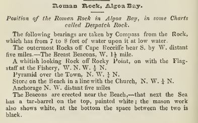
Notes per E.P. Directory & Almanac of 1848:

Sources:
Port Elizabeth in Bygone Days by JJ Redgrave (1947, Rustica Press)
E.P. Directory & Almanac of 1848
Port Elizabeth: A Social Chronicle to the end of 1945 by Margaret Harradine (1996, E H Walton Packaging Pty Ltd, Port Elizabeth)
Letter from Port Elizabeth Harbour Master (Dunsterville) to Colonial Secretary in Cape Town [Port Elizabeth Letter Book number M164 (courtesy of Jon Inggs)]