

We have all heard about the strong possibility that San Francisco could experience further devastating earth quakes but how many residents of Port Elizabeth are aware that the city has three ancient fault lines under its surface.
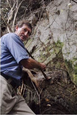
Main picture: Fault lines in Target Kloof
Geological history
Most of Port Elizabeth is built on quartzites and hard sandstones of the Table Mountain series, which are around 300 million years old. Exposed at Sardinia Bay is a narrow coastal strip of the underlying Pre-Cape system which is probably twice as old, and which includes the Maitland mines and the Loerie limestone. To the north are younger Cretaceous rocks of the Uitenhage system (about 120 million years old), sandstones, mud-stones and clays, which include good brick-making materials. The most recent deposits are marine in origin and contain exciting fossils.
According to Professor Booth
The rocks along Port Elizabeth’s littoral are part of what constitutes the Cape Fold Belt or CFB. The CFB rocks can be defined as being an area of rocks of recognisable type and origin that occurs all along the southern coastline of South Africa [from Port Alfred to Cape Town and then northwards to Vanrynsdorp], a distance of some 1200kms. The Cape Fold Belt extends inland for about 200kms from the southern coastline.
The geological history of the Cape Fold Belt commenced some 400 million years ago when the earth’s crust was stretched and thinned. This south directed action then formed the edge of a large tectonic plate, the stretching being facilitated along near horizontal fault planes. Then followed an extended period of accumulation of sediments that were continually being deposited in layers along the developing continental margin under similar physical conditions to our present coastline. This period of sedimentation proceeded for 100 million years and built up a thickness of 10 kilometres of sand and mud deposits.
At about 300 million years, tectonic forces changed their orientation and began pushing northwards. This shoving action pushed the package of sediments into a series of folded strata resembling a contorted Dagwood Sandwich and probably reached heights similar to today’s highest mountain range, the Himalayan Mountain Belt. The resulting Cape Mountain Range, which survives today as the Cape Folded Belt, has been much eroded since it was formed especially since the massive continent of Gondwana broke up some 200 million years ago and today its highest peaks reach only just higher than 2000 metres about sea level at the Swartberg Pass.
During recent geological times, the sea has planed off some of the mountain belt close to the present sea level much in the same fashion as using a giant horizontally-orientated saw, leaving terraces near the coast at differing heights above and below the present sea level. These old marine terraces developed in response to past changes in climate, especially with regard to ice ages with their corresponding lower sea levels and periods of greater heat than are being experienced at present with their higher sea levels.
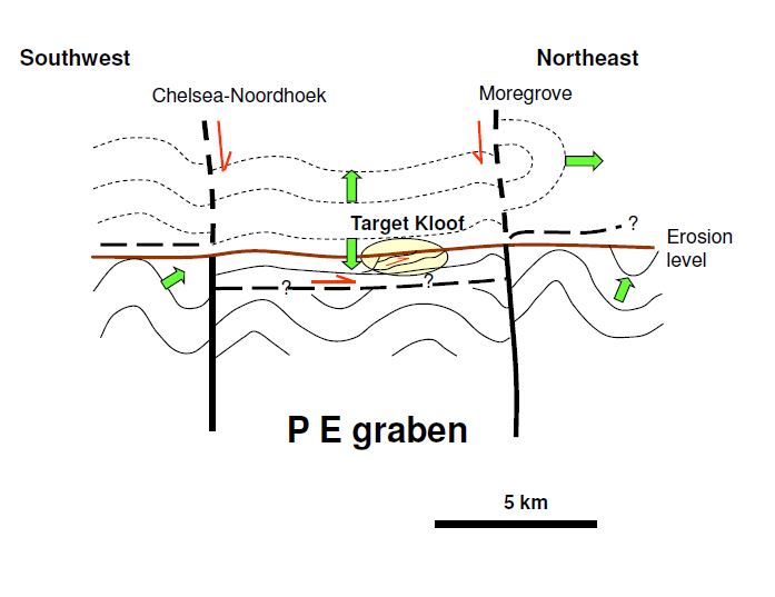
Location of Fault Lines
According to the Geocaching blog, these fault lines are located as follows: “One of them, the Moregrove Fault, runs along the Port Elizabeth beachfront from Pollok Beach, Summerstrand, along the shoreline, through the Baakens Valley and ending at the Moregrove quarry near the Kragga Kamma interchange.” Another, the so-called Chelsea-Noordhoek Fault, runs parallel to the Schoenmakerskop coast, while a third fault runs in the Coega area.

Creation of the faults
Dr Steffen Buettner, senior lecturer at Rhodes University, said: “Major seismic activity in the region was linked to the break-up of the super- continent Gondwana (about) 150 to 125 million years ago”. “At that time, the Earth’s crust was stretched and extended, forming faults, fractures along which crustal blocks moved downwards. “The major tectonic movements came to an end more than 100 million years ago, and what causes occasional tremors nowadays is just an aftermath which is not likely to end up in a significant earthquake”. – Source – The Herald

“The shock was felt most severely towards the north and west ends of the town. It was sufficient in these quarters to move lighter articles, such as glasses, mantle-piece ornaments, etc, from their places,” the Herald reported.
Recently recorded local earthquakes and tremors
One of the town’s earliest recorded earthquakes struck at 10.15pm on Tuesday, 21st May 1850. The shock was not very severe, but “sufficient to alarm the more nervous members of our population and to awaken from their first slumbers those who had retired at a very early hour to rest,” reported the Eastern Province Herald. The earth shook for about a minute and those inside their homes described the shaking as though it were a very violent wind. The newspaper reported that there had not been an earthquake in the young town before.
After the earthquake had subsided, most residents went outside to inspect their buildings for damage. The air was very still and a heavy dew had descended. Several people said they had perceived a sulphurous smell during the earthquake. There are reports in Morse Jones’s Lower Albany Chronicle in which it was noted the tremor was also felt in the Lower Albany area and had been violent enough to inspire the local Xhosa community to come up with a special word for it: inyikima.
In January 1900, a quake was felt in the Tsitsikamma area strong enough to dislodge crockery from shelves in some houses. Another tremor was felt in Port Elizabeth in 1912.
On 4th December 1920, a tremor lasting about 20 seconds occurred. It was the result of a strong earthquake out at sea and was felt in Port Elizabeth, Cape Town and George.
In 1929 an early morning earthquake large enough to cause damage to buildings was felt in Grahamstown. This was followed on 9th August 1932 by a fair-sized tremor felt in Alice, Queenstown and Graaff-Reinet.
There have been several other occasions when Port Elizabeth felt the earth shake. At 3am on 12th January 1968, a tremor shook the Eastern and Southern Cape and was felt in Port Elizabeth, Uitenhage, Mossel Bay and Graaff-Reinet. It lasted about two minutes and was strong enough in Uitenhage to cause furniture to move and pictures to fall from the walls of homes.
In Joubertina, Leon Olivier, 14, was shaken off his bed. A glass containing false teeth, which was knocked off a table, became a talking point.
On 3rd October 1977, a tremor felt at many places in Port Elizabeth between New Brighton, Summerstrand and Seaview, was recorded in Pretoria. It would not be the last.
The Herald reported that at 8.55pm on Sunday, 6th October 1986, a strong tremor – registered at 4.9 on the Richter scale – “rocked buildings and sent people fleeing from their homes” as it rippled its way through large sections of Natal and the Eastern Cape. The tremor was felt in Port Elizabeth, East London, Aliwal North, Queenstown, Elliot, Mthatha and Durban. A caller to The Herald said it had been violent enough to knock ornaments from a table. On the Port Elizabeth beachfront, residents in Mutualhof (now The Beaches) in Humewood and Marine Towers in Summerstrand reported a severe shaking which “seemed to last a few minutes”. Residents in Swartkops, Greenbushes, North End and Kini Bay all reported feeling the tremor.
Dr Robert Kleywegt, of the Mineral and Energy Affairs Department, said at the time that coastal towns and cities were particularly prone to the effects of minor tremors. “Along the coast, a lot of high-rise buildings are on poor foundations – piles driven into waterlogged sand”. It is believed that the tremor’s epicentre was in Lesotho or the north- eastern Cape.
The worst earthquake to hit South Africa struck on 29th September 1969, when nine people were killed in the areas of Tulbagh, Prince Albert, Ceres and Wolseley during a 6.5 magnitude earthquake. Damage, which included many historic buildings in Tulbagh, totalled R20-million.The most recent earthquake occurred two months ago – on December 1 – 10km off the Transkei coast.
South Africa as a whole does not normally get large tremors except in the Witwatersrand where they result from mining activities.
Visible evidence of these faults
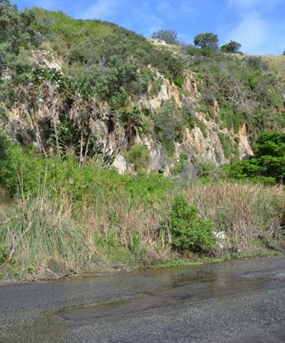
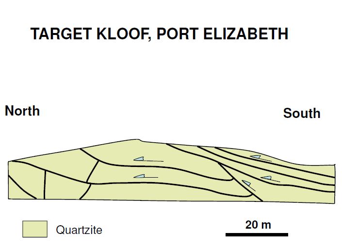
In some places in the Baakens Valley the quartzite rocks of the Moregrove Fault are visible. The old sandstones have been heated to such an extent that all the grains interlock, making it a very hard rock. One side of the rock has dropped down relative to the other as a consequence of Pangea breaking up and the formation of the super-continent Gondwana. Its this drop that has formed the fault. The water which continually runs across Lower Valley Road near the old PE Tramways building is underground water seeping to the surface through the Moregrove fault. This fresh water used to flow into the fresh-water lagoon that was situated at the mouth of the Baakens River. The lagoon was filled in at some stage and the river contained in a channel which is only about two meters wide at this point today. The water now forms a vlei area next to the cliff before flowing over the road and trickling down to the river.
None of these fault lines will affect me as I live in Joburg, but what about the disused gold mines?
Sources
The Geology of Schoenmakerskop by Professor Peter Booth, NMU (Looking Back, Volume 57, 2018)
https://www.geocaching.com/geocache/GC55T74_port-elizabeth-ancient-fault-lines
http://www.inkaba.org/publications/workshops/workshop6/moodley_abstract.pdf
Coega is supposed to be going to get a nuclear power station.