

The success of Port Elizabeth has always been determined by its transport links to the interior. Initially it was the port from which the bulk of the Cape Colony’s wool was exported and then in the first half of the 20th century it was the port through which all cars assembled in South Africa were imported. Before the introduction of rail services in the 1870s, inland transport was dependent upon the state of the roads which were execrable. Secondly the condition of the roads impeded the exports in that it took three months for an ox wagon to complete a round trip from Graaff Reinet to Port Elizabeth and back.
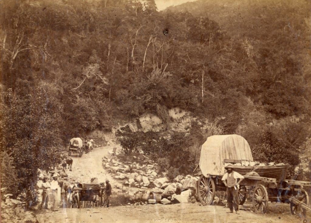
Main picture: Typical old Divisional Council roads, narrow and rutted, with a drift below and ox wagons toiling up the hill
In his excellent thesis Liverpool of the Cape: Port Elizabeth Harbour Development 1820-70 Jon Inggs succinctly summarises the transport conundrum as follows. “The common denominator between all of Port Elizabeth’s major exports was the fact that they were all bulky items, with a relatively low value to mass, produced in the distant interior. Thus their viability as exports depended more on the state of inland transport than on the existence of harbour facilities. The nub of the transport bottleneck was that before the advent of railways in the 1870s, eastern Cape transport was dominated by the humble ox wagon. Instead of casting aspersions at its lumbering appearance and rutted tracks deemed to be roads, they were able to cope with the massive expansion of trade. The exact number will never be known but by using wool export data from the Customs Returns, one is able to obtain a fairly accurate notion of the magnitude of these loads. Fully laden, each wagon is capable of carrying about 20 bales of wool with a mass of 3000 kgs.

In many instances where figures are available, the number of wagons transporting wool to Port Elizabeth was in fact far in excess of the above estimates.

Distances covered by the wagons
It was not just a case of vast distances being covered but due to the fact that the wagons travelled painfully slowly, it can be deduced that most wagons entering Port Elizabeth had been on the road for at least a month. This time was based upon the estimated travelling distance per wagon being 193 kms.
Increased competition depressed transport costs substantially as follows:
During the shearing season, wool was obviously the dominant cargo. Therefore the bulk of wagon traffic was from the major wool growing regions to Port Elizabeth. In 1853, the districts of origin of the wool exported through Algoa Bay.

As Jon Inggs correctly notes is that “Port Elizabeth owed its importance to the fact that it was the natural outlet to the sea for the major wool producing districts. She maintained her position so long as inland transport depended on the ox wagon”. The introduction of the railways in the 1870s would change this dynamic.
Importance of the road network
From the foregoing, Jon Inggs clearly lays out the statistics illustrating not only the importance of this road network to the rise of Port Elizabeth but also the surprising conclusion that the importance of the road system was greater than the existence of the harbour facilities. Clearly the shipping companies never viewed the road network as a larger constraint than the lack of harbour facilities.
Simply put the term “road” was a misnomer as these arterials were in fact little more than deep wagon tracks. When parts deteriorated and became unusable, that section was bypassed, and a parallel track developed. In theory the owner of the land, over which a main road ran, was responsible for its maintenance and upkeep. Thus a variant of the concept of the Tragedy of the Commons was experienced as regards these roads. A lackadaisical attitude to repairs ensued with the tardy local farmers lethargically filling in ruts with loose material. It is safe to say that the farmers possessed a mitigated factor for the lack of maintenance as the sheer volume of traffic over the most important roads made adequate maintenance an impossibility.
Inggs laments that “until the 1840s, the government did precious little to keep Eastern Cape roads in good repair apart from setting up tolls, such as the one at Port Elizabeth”. Much like the current fiscal practice of not ring-fencing income for a specific project or budget line item, the Colonial Government merely treated this income as part of the pool of revenue. Even though it was theoretically deemed to finance road maintenance, it was rarely utilised for local road maintenance.
“The main reason for the “execrable condition” of the Cape roads was the colony’s general lack of funds. Therefore as was the case with local harbour development, it was left to private enterprise to take the initiative. Grahamstown residents, for example, subscribed funds for a new road through Howieson’s Poort in the early 1830s. But this kind of venture was always undercapitalised, and the roads involved usually little better than the rest. Other improvements were limited to privately operated punts at the major rivers and numerous inns to accommodate wealthy travellers”.
The first ray of hope for improvement in these rutted roads which ineluctably compelled the ox wagons to a slow walking pace arose in 1838 with the appointment of a new governor, Sir George Napier. One of the immediate needs that he identified was the upgrading of the Port Elizabeth – Grahamstown road. Faced with the prospect of further Xhosa incursions across a porous border, the army also expressed an interest in road construction. It was the treasury which had to express their displeasure at this suggestion in the starkest terms claiming that the treasury’s cupboards were bare. To rub salt into the treasury’s wounds, the Government Engineer, Major CC Mitchell, in the late 1830s revived interest in a general colonial road scheme. The adoption of this scheme would have spread the limited funds over a vaster distance much like attempting to feed the multitude with one container of peanut butter.
It was during the 1840s that three factors combined to bring the proverbial road pot to the boil again. Firstly aside from the rapidly expanding wool trade with its increasing volumes, the new prosperity generated revenue which could be applied to road building. Secondly “the continued disturbed state of the frontier awakened official and public opinion to the necessity of good roads. It was not until 1843 that the………………..master mind of John Montegu [found] convincing formulation and support.
This was to result in Montegu setting up a central road board which were supported by a series of local boards. For this purpose, they utilised the colony’s convicts exclusively for the construction of the main roads. “Unfortunately the main consideration was the improvement of communications between Cape Town and the Frontier”. Naturally Port Elizabeth, much to their chagrin, wanted their town to be the hub of the road network in the Eastern Cape. Bypassing Port Elizabeth fanned the flames of the Separation fire as the residents of the region once again considered themselves the spurned bride at the nuptials.
The next colonial official to take up the cudgels on behalf of the Eastern Cape in 1847 was the newly arrived Lieutenant Governor, Sir Henry Young, an ardent separatist. Almost immediately, he reported the deleterious effects of Montagu’s road system on the Eastern Province. These protestations fell on the deaf ears of Executive Council which promptly rejected his concerns on the basis that Montagu’s system was to be given a 7-8-year trial period.
Inggs notes that “It has been shown that the western dominance of Montagu’s road system has been grossly exaggerated. In fact, the eastern districts got 25% more from Board Funds than it was entitled to between 1844 and 1855”. Road building was held up due to spite but rather due to other exogenous factors. Construction was interrupted due the outbreak of the War of the Axe from 1846 -47. Work was suspended until 1848 when 250 convicts were allocated to the priority project viz the Zuurberg Pass. Its status as a priority arose from the necessity to bypass the circuitous route via Grahamstown for traffic from Cradock and Colesberg. Further work after the completion of the Zuurberg Pass in 1850, was delayed due to the outbreak of the 8th Frontier War from 1850 to 1853. The reopening of the Zuurberg Pass in December 1853 was the swansong of Grahamstown as an important commercial centre.
The status quo was maintained until 1864 when the Divisional Councils were made responsible for maintaining government main roads.
Source
Thesis of Jon Inggs, “Liverpool of the Cape: Port Elizabeth Harbour Development 1820-70“, MA thesis, Rhodes University, 1986