

Interfering with Mother Nature might not produce a Newtonian response i.e. an action is followed by an equal and opposite reaction. Rather it generates sometimes arbitrary unintended consequences but responses nevertheless. In the case of Port Elizabeth, there has been interference with nature on a vast scale in the southeast area relating to the driftsands and the dune fields.
The ultimate consequence of these ill-conceived projects to redirect nature will result in the denuding of all the main beaches in Port Elizabeth, stripping Port Elizabeth of a potential lucrative tourist asset.
Main picture: Map showing the dune field systems in 1890. Summerstrand and Humewood were just one big sand dune
History lesson
Development always disturbs nature’s homeostasis. Instead of being unconstrained, humankind fragments nature in a whole of plethora of ways. Dams, roads, pipelines, fences, channels are some of the methods that humankind employs without oft times considering its effect on the ecosystem.
This is what happened with the sand issue.
Historically the beach front from Cape Recife to Humewood was characterized by three main driftsand areas, known as Driftsands, Noordhoek and Cape Recife. These mobile dune systems were separated by naturally stable vegetated dunes.

In the distance onthe right are huge sand dunes covering the whole of what was to become Humewood and Summerstrand
What was nature doing? The predominant south west wind would shift the sand slowly but inexorably west from the Wild Side to the Bay. Photographs taken in the infancy of photography clearly indicate that Humewood was one giant sand dune. Furthermore, research showed that the predominant source of sand for the beaches along the Cape Recife to harbour stretch was from these three dune fields. As the Harbour Board fretted that the largest of these dune systems would veer off its historic trajectory and overwhelm the harbour, some action had to be taken to prevent this envisaged catastrophe.
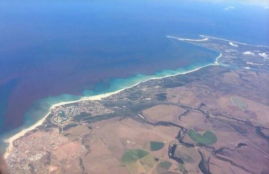
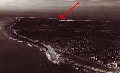
Aerial view of Humewood, Summerstand and Cape Recife today showing that the dunes have been replaced by vegetation and suburbs
What these bureaucrats failed to recognise was that the Bay received around 170,000 m3 of sand a year from the dune systems. Driftsands is actually the dune system that starts in Sardinia Bay, and in those days used to track over the peninsula, right past where the airport is today, and empty into the sea between Happy Valley and Bird Rock. It was a fallacy that the harbour would be inundated with sand, as there is historical evidence of its existence long before the first settlements in the area.
The main sand bypass system, known as Driftsands, covered the area between Schoenmakerskop and Summerstrand. In order to remove the threat of these moving dunes to the young town of Port Elizabeth, plans were devised in the last 1800’s to stabilise them. At first a steam train was used to dump the town’s garbage on the dunes and you still find areas where pieces of old bottles, plates and other objects can be found. In the beginning of the 1900s, the area was stabilised by planting Australian wattles such as Rooikrans and Port Jackson as well as Eucalyptus trees in an attempt to start a commercial forest.

Source of the Driftsands Dune field, the sand dunes at Sardinia Bay
With the main source of sea sand for the main beaches now blocked, these beaches now had to rely on the infinitely smaller more easterly fields – Noordhoek and Cape Recife. To add insult to injury to nature, in an almost Machiavellian move, the larger of the two fields was itself blocked in the 1960s by the construction of sewerage maturation ponds at Cape Recife.
As they fell directly in the path of the moving Noordhoek dune field, so the leading edge of the dunes had to be stabilised by planting vegetation. To avoid the developing residential area of Summerstrand from becoming inundated with sand, both the Driftsands and Noordhoek dune systems were substantially reclaimed from around the 1970’s.
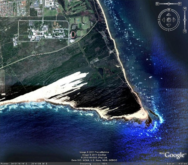
Noordhoek driftsands blocked by the sewerage maturation ponds at Cape Recife
After Driftsands was reclaimed, the sand entering the bay from the remaining two dune systems dropped to around 78,000 m3 per annum. Then in the early ‘70s, after Noordhoek was also reclaimed, it dropped even further to only 26,000 m3 per annum, which was coming from the small dune field at the lighthouse at Cape Recife.
That represents a 75% decrease in the amount of feeder sand that the Port Elizabeth beaches are receiving.

Aerial photo from 1930 showing Noordhoek dunes going right across Cape Recife
Little wonder they disappearing!
Reversing course
Kings Beach is the only beach in the city that has enlarged over the years, now almost extending to the end of the breakwater. In photos taken before the turn of the 19th Century, King’s Beach was a narrow strip all the way to where the breakwater commences today. Would it not be possible to pump the extra sand building up at Kings and to the east of the harbour entrance up towards Pipe so that it could drift back down? The city could also motivate Transnet to take the sand it dredges from the port entrance channel and discharge it in the vicinity of Pipe, but it would be unlikely to get this right due to environmental authorisation and the obvious cost implications.
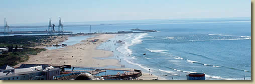
Formerly King’s Beach was a narrow beach whereas currently it is 100s of metres wide
Yet another solution would be to re-activate the Noordhoek dune field. The natural path of the sand is to blow from the Wild Side, across the Cape Recife headland, and towards the Bay. It is a fairly narrow dune field, only about 500m across which will likely enter the bay just south of SAMREC in Cape Recife. When the sewerage maturation ponds where built in Cape Recife back in the 1960’s, they fell into the path of the moving dune field, so the leading edge of the dunes were stabilized by planting vegetation. The re-activation of the dune fields would essentially entail stopping the prevention of the natural flow of sand through this stabilization, and let it revert to just following its course. Removing the stabilizing vegetation would speed things up even further. In time this would see the Noordhoek dune field cut right across Cape Recife as it did in the past and feed sand back into the top of Algoa Bay. It is anticipated that it would add 15% to the current sand volume entering the Bay.
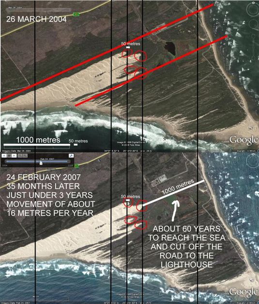
Comparison between 2004 and 2007, showing a 16m growth of the dune field. Image courtesy Glendore Sand
This would go a long way in helping to replenish the town’s beaches, as it would become a regular supply of feeder sand. Sand fed into the sea from the dunes would drift down towards the Bay’s beaches due to the natural long shore current that sweeps from the tip of Cape Recife into the bay.
There are potential negative consequences of reactivating the dunes as over time the dunes would cover the settling ponds at the sewerage works. This would not happen overnight though; it may take a few years at least. It would most likely also only affect the ponds, not the main infrastructure of the sewerage works. Obviously there would be some cost implications to move the ponds, but the municipality would still have a few years to find the budget to move them out the way before the dunes reach them.
Aerial photo from 1971 showing how dunes had receded
If a way was found to utilize all the grey water produced by the sewerage works, for example using it to water the golf course and the parklands along the beach, then there would not probably even be a need for the ponds. At this stage they just store the treated water whilst it is waiting to get used.
It is estimated that it will take the dunes about 55 years to reach the beach. At the moment they are about 1km away, moving at a rate of around 16m a year. This assumption is based on comparison of aerial photographs taken in 2004 and 2007. If an active effort was made to clear a path for them, and remove the stabilizing vegetation at the leading edge of the dune field, then it might speed things up a fair bit. If the volume of this sand is insufficient, it would be impractical now to re-activate the northern most dune field as this field crosses the southern portions of the airport, the Walmer Location and much of Humewood.
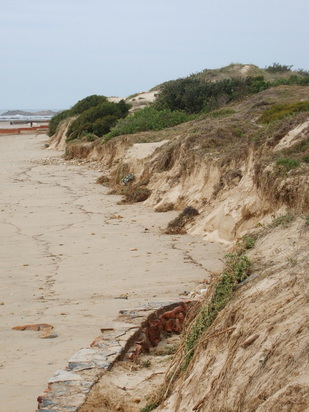
Dunes being eroded at Millers, from the end of the sea wall
One solution not yet on the table would be to pump sand from Sardinia Bay through to the northern beaches.
Conclusion
Naturally expecting our forefathers to perform a comprehensive environmental impact assessment would have ludicrous, yet if some forethought had been given to the environmental consideration, would it not have been preferable to let nature recycle the sand in the Bay based upon a system that had been tried & tested over eons rather than to let man attempt to manipulate it?
Sources
http://www.millerslocal.co.za/getting-our-beaches-back.html
https://www.geocaching.com/geocache/GC63X4F_noordhoek-dune-field
http://www.millerslocal.co.za/pes-disappearing-beaches.html
http://www.millerslocal.co.za/blog/draft-nmbm-coastal-management-plan
Glendore Sand & Stone